A Geotechnical Report that Southern California professionals rely on is far more than a checklist item for permits. It is a scientific investigation into what lies beneath a construction site. This report tells you if the ground can support your structure safely and for the long term.
It is prepared by licensed geotechnical engineers or engineering geologists. This report includes soil sampling, subsurface testing, and seismic hazard analysis.
It combines field observations and laboratory results into one essential document. It gives your design team a clear picture of what they’re building on. Hence, it can identify the risks they need to avoid.
Southern California’s geology is complex. Earth terrain varies from clay-rich valleys to fractured rock hillsides. Mistakes in foundation design can lead to cracking, shifting, or worse.
So, without proper investigation, the risk of structural failure is high. That’s why every major city, from Los Angeles to Santa Monica, mandates a geotechnical report for many types of construction.
Why Are Geotechnical Reports Essential in Southern California?
Southern California sits on some of the most active seismic zones in the United States. Earthquakes, landslides, and liquefaction are not hypothetical. They are expected events, especially in the US.
The California Geological Survey (CGS) has mapped high-risk zones across the region. It helps to identify where these threats are greatest.
In addition to earthquakes, Southern California’s terrain includes steep slopes, urban fill, and shallow groundwater. These conditions create even more risk for foundations, retaining walls, and underground utilities.
If you are constructing in a Hillside Ordinance area, you will need to submit a Geotechnical Report. This report must be accepted by the permitting officers in Southern California.
Cities like Los Angeles (LADBS) and LA County rely on this report during plan check. It is used not only for approval purposes. But it also protects public safety and ensures the structure can stand for decades.
What Happens If You Don’t Submit a Geotechnical Report?
Skipping a geotechnical report is risky—and often illegal. If your project falls within a mapped hazard zone, you must submit the report to obtain a permit.
Similarly, if the terrain requires grading, you need the geotechnical report. Without it, the city may reject your application outright or place your project on hold.
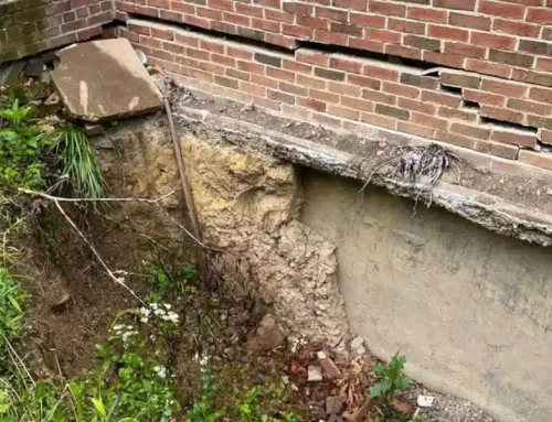
Even if a permit is issued without a report, future problems can be severe. However, this is a rare case, but it is possible for small projects. If foundations settle or walls crack due to poor soil conditions, you may face repair costs.
Not only this, it can also lead to lawsuits, or denied insurance claims. And if there’s an earthquake, any damage caused by avoidable soil failure may not be covered.
In short, a Geotechnical Report in Southern California isn’t just a safety net. It is your first layer of protection against construction failure, delays, and liability.
Who Reviews and Uses This Report?
Once submitted, the geotechnical report is reviewed by city and county agencies. These include LADBS, LA County Building and Safety.
In many cases, the state agencies like Caltrans handle this. For large-scale infrastructure, agencies such as LA Metro also require these reports. They are responsible for reviewing the reports of transit projects in Los Angeles.
But it is not just government reviewers who rely on the report. Civil and structural engineers need the data to design safe foundations.
It also helps them to grade the site properly. Architects use the report to set floor elevations, basement depths. These reports also ensure their plans are buildable.
Contractors depend on the report during construction. It tells them where to dig, how to compact the soil, and how to prevent water intrusion. The geotechnical engineer often returns during grading or excavation to verify soil conditions. Hence, they are capable of issuing site-specific instructions.
Read more to find out What Happens If You Don’t Submit a Geotechnical Report?

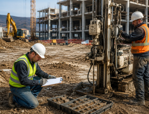
Geotechnical engineers conducting on-site soil sampling in Los Angeles County as part of a Geotechnical Report Southern California projects require for grading and foundation design.
How a Geotechnical Report Helps the Design Team?
The value of a Geotechnical Report to design teams becomes clear on the design stage. Without verified soil data, engineers are guessing. That can lead to over-engineering (which is costly) or under-engineering (which is dangerous).
The report provides parameters for the foundation type. It determines whether shallow footings, piles, or caissons are needed. It also outlines compaction requirements for backfill. The report data decides the pressure calculations for retaining walls. It also provides the waterproofing guidelines when groundwater is present.
For sloped sites, the report offers slope stability modelling. This allows the engineer to plan retaining walls, cut-and-fill ratios, and erosion control strategies. Without this information, a designer risks violating code. He may even go for worse, that is, building something unsafe.
What’s Included in a Geotechnical Report?
Here we have a detailed structure of a report. However, it may vary according to site conditions and project requirements.
What Happens After the Report Is Submitted?
After submission, the report goes through a plan check with the local agency. Once approved, it becomes part of the official plan set. From this point forward, the site must be constructed following the report’s recommendations.
If soil conditions differ during excavation, the geotechnical engineer may issue revised recommendations. Upon completion, they issue a final letter of compliance. This letter confirms that all work was done per the report.
This letter is often required for the city to issue a Certificate of Occupancy. This is a legal document needed to use or sell the property.
It may be referenced in the event of a dispute or future development. Reports may also be used during future renovations or property sales to show due diligence. A copy of the final report is often retained by the building department.
What Does a Geotechnical Report Cost in Southern California?
Costing comes with the advancement and requirements of the project. So, the price for a geotechnical report varies.
A flat lot might cost $3,000 to $6,000. A hillside site could cost $10,000 to $20,000+. Commercial and public works jobs can exceed $50,000.
It depends on some factors, and these may include:
- Number and depth of borings
- Lab testing scope
- Site access challenges
- Fault trenching needs
- LADBS peer review
However, costs can also rise due to other factors. It may be weather, traffic control, or unexpected soil conditions. These conditions refer to buried debris or fill
Skipping the report is risky. Without one, you could build on weak or shifting soil. That can lead to cracks, water intrusion, or structural collapse.
Cities may halt the project. Insurance may not pay for damage. You could face lawsuits, delays, and costly repairs.
Geotechnical reports reduce risk. They help avoid future problems. They save money in the long run. They provide confidence to all stakeholders.
You can explore some of the noble institutes on behalf of this field. For example, Caltrans Jobs, Metro Careers, or City of Los Angeles Jobs. You can join infrastructure and inspection teams that rely on these reports.
Final Thoughts
Final Thoughts
A Geotechnical Report Southern California Builders Trust is one of the most important tools for ensuring safety and compliance. It gives you real data, not guesses, about the ground below. It helps prevent failures before they start. And it allows your design and construction teams to move forward with clarity.
Whether you’re building a hillside home, a commercial complex, or an underground station, never skip this step. A quality report may cost a few thousand dollars, but it can save you millions in the long run.
Build with knowledge. Build with confidence. Build smart from the ground up.