Introduction to Debris Flow Risks
As wildfires are increasing in California, the burnt area every year is getting larger. Moreover, these fires destroy plants and damage the land’s surface. After extinguishing, it is not too late. Actually, a new risk is initiated.
Slopes that are burned are unstable. The ground is made loose. Plants that used to bind the soil together are missing. During the rains, it collects swiftly down the slope. It carries rocks, dirt, debris, and trash with it. This forms a flowing debris.
Debris flows are rapid and intense. They may take place quite unexpectedly. They can demolish houses and damage infrastructure. They can even reroute the roads. The most likely time of highest risk is during the first season of rainfall after a wildfire.
This is why it is significant to conduct the risk assessment of debris flow. Burned areas are a matter of study for engineers. They consider the rain, soil, and slopes. They determine perilous areas. This helps safeguard communities and infrastructure. This article will discuss how the flow risks of debris are determined after the wildfires in California.
What are Debris Flows?
A rapidly moving mixture is referred to as a debris flow. It has soil, rocks, ash, water, and vegetation. It flows like an air-concrete down. Streams of debris generally originate on a steep slope. Once started, they are soon on a roll. They grow too, growing in size.
Difference Between Debris Flow and Landslides
Debris flows are fluid-like. They are fast-moving and drainage systems. Landslides move differently. They entail a lot of earth or rock slipping down. Both are dangerous. But the flies of rubbish are more rapidly pushed along, and become dispersed over a greater distance.
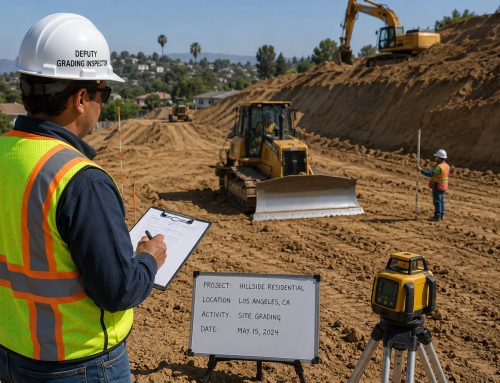
The Phase 1 testing for construction helps prevent project delays and closures. Properly framed inspections safeguard schedules, jobs and project budgets. The Los Angeles Department of Building and Safety says visual checks help catch early problems.
Read more to find out why it’s important to retain a Geotechnical Engineer on-site for your fire rebuild projects to help properly develop a property and construction stability, along with avoiding health concerns.

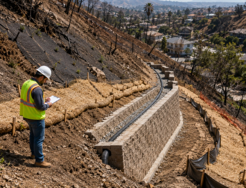
Engineers conducting debris flow risk assessment in a post-wildfire burn scar area in California, evaluating slope instability, runoff channels, and potential mudflow hazards to protect nearby roads and infrastructure.
Why Debris Flows Are Dangerous
Loss of Vegetation
There are heavy boulders in debris flows. They also transport trees and heavy debris. They are very fast. Within seconds, they can demolish structures. They also cause obstructions on roads and drainage systems. This increases the risk of flooding. This is why, in the initial stages of risk assessment, it is crucial.
Why Wildfires Increase Debris Flow Risk
Vegetation holds the soil particle. The ground is gummed by roots. This vegetation is burnt by wildfires. The soil is rendered loose and unstable. The lack of roots increases the likelihood of slope failure.
Soil Hydrophobicity
Wildfires change soil behavior. The soil that is burned may get water repelling. This is termed as hydrophobic soil. It does not easily get soaked. Rather, the water is running on the surface. This increases runoff.
Increased Surface Runoff
When the soil absorbs the water, it is due to poor drainage. Run off collects the loose debris. Growth to a debris flow. Such events may be caused by even minor storms.
Burn Scar Areas
The most hazardous areas are the areas of burn scars. There was a severe fire in these places. Soil is loose. Vegetation is gone. There is a change in drainage patterns. These aspects need to be evaluated thoroughly. Such agencies as the California Geological Survey map burn scars and locate high-risk locations.
Key Factors for Debris Flow Risk Assessment
Rainfall Statistics
Although intense rainfall is risky. It can initiate debris flows in a short time. Rainfall thresholds are observed by engineers. These assist in forecasting the occurrence of risks.
Slope Gradient and Topography
Steep slopes are more dangerous. Down the slope, water travels faster. Narrow valleys also enhance the flow force of this debris. Topography is very significant in assessment.
Soil Type and Condition
There are more vulnerable loose soils. Fine-grained soils are easy to move around. Torched soils are less in strength. They do not absorb as much water. Risk is determined based on soil testing.
Watershed Characteristics
Watersheds collect runoff. Very large watersheds produce more debris. Patterns of drainage are examined. The size of the catchment is also researched. These are used to determine the volume of flow. Methods of Site Investigation, post-wildfire.
Post-Wildfire Site Investigation Methods
Field Surveys
Engineers go to the burnt areas. They monitor the conditions of a slope. They determine the severity of the burn. They determine loose soil areas. The valuable data can be obtained through field surveys.
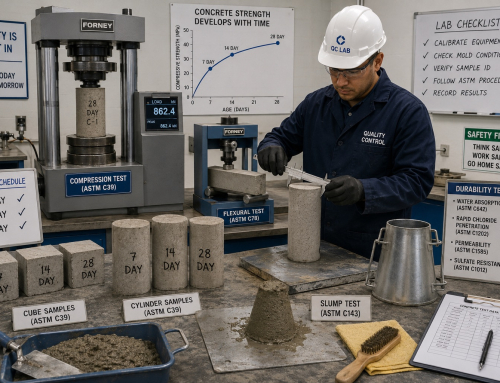
Soil Testing Analysis
Sampling of soils is carried out. Permeability and cohesion are tested by engineers. These tests demonstrate how soil behaves when it is raining. Poor soils enhance the risk of gully.
Remote Sensing and GIS Mapping
Satellite pictures are employed. Maps of burn severity are developed. GIS has tools that study topography and drainage. It helps in identifying risk-prone areas in quickly.
Mapping tools are used by organizations such as Caltrans to safeguard highways and infrastructure following wildfires. Agency’s role in Risk Assessment.
Role of Agencies in Risk Assessment
United States Geological Survey
The US Geological Survey has hazard maps to offer. They as well come up with rubble stream models. Predicting potential events using these tools is possible. Their information aids the emergency plan.
FEMA
The Federal Emergency Management Agency offers guidance in dealing with risk management. They assist the communities in making preparations. They enhance the recovery from disasters.
CAL Fire
California Department of Forestry and Fire Protection annual reports provide fire statistics. They release maps of the severity of the burns. These maps assist engineers in determining risk. Simulation and estimation of debris flows.
Modeling and Prediction of Debris Flows
Empirical Models
Rainfall thresholds are applied in the empirical models. They approximate the times when debris flows can occur. Such models are merely basic. They can be used to make a quick evaluation.
Numerical Modeling
The complex software is used to simulate debris flows. The data are entered by the engineers with slope and soil data. The model predicts the flow paths. It is also used to estimate volume and speed. This assists in developing mitigation measures.
Early Warning Systems
Systems for monitoring rainfall are in place. Storm intensities are monitored by sensors. In cases that exceed rainfall limits, alarms are provided. Local agencies issue warnings and safety precautions for high-risk zones. For example, the Department of Building and Safety of Los Angeles.
Mitigation Strategies
Engineers also test construction materials. These include sand and gravel. Good materials make structures stronger.
Structural Measures
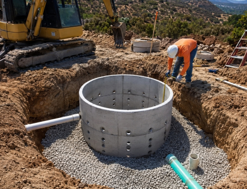
Debris basins are constructed by engineers. These are used to capture flowing material. Also, retaining walls are employed. They protect structures. A check dam slows down the flow. These are measures that minimize damage.
Non-Structural Measures
Planning land-use is significant. Development of high-risk areas is not advisable. Emergency evacuation plans should be made. The communities are to be educated. The following measures enhance safety.
Vegetation for Slope Stabilization
Planting trees stabilizes the slopes. Controlling erosion blankets are implemented. They reduce runoff. Mulching also enhances soil stability. These approaches decrease the risk of debris flow.
Real-World Impacts and Case Examples
Post-Wildfire Events in California
Since wildfires, numerous debris flows have occurred in California. Destructive events have been brought about by heavy rainfall following the fires. These are flows that destroyed homes and structures.
Damage to Infrastructure
Debris tends to clog the roads. The bridges can be blocked. There is clogging in the drainage systems. Flooding increases. There are impairments in transportation networks. The post-disaster efforts train agencies such as the State of California and county governments to spend a lot of funds on mitigation.
Lessons Learned
Early diagnosis helps to save lives. This is minimized by warning systems. Effective planning is conducive to reviving communities. These are lessons to govern future risk management.
Challenges in Debris Flow Risk Assessment
- It is unpredictable weather. The weather patterns of rain alter quickly.
- Areas that have been burnt are inaccessible. Conditions change rapidly.
- Information can be scanty.
- The wildfires bring about different conditions. All these complicate the assessment.
Best Practices for Engineers and Planners
Early Risk Assessment
The first assessment of the extent of a wildfire should take place as soon as the fire has been extinguished. This will give time to mitigate. The sooner, the better.
Integrated Approach
A combination of field surveys and modeling should be made. Accuracy is enhanced by remote sensing. Combinative approaches are more effective.
Community Awareness
The residents should be aware of the risk. Posters of warning signs are to be put in place. Routes should be arranged towards evacuation. Public awareness increases the safety.
Engineers help plan long-term maintenance. They identify the risks and suggest suitable preventive measures. They guide the owners to maintain the site. This reduces future repair costs.
Conclusion
Wildfires transform the landscape. They take away vegetation and undermine slopes. Usually, during the post-fire period, debris flows pose a great danger.
Quick flows may occur as a result of rainfall. Soil, rocks, and debris are transported by these flows. They have the potential to harm homes, roads, and infrastructure.
Risk assessment of debris flow can be used to identify risky areas. One who is going to be an engineer is studying slopes, soils, and rainfall. They apply field surveys, testing, and modeling. Mitigation intervention is possible through early assessment. These consist of debris basins, slope stabilization, and warning systems.
Lives and property are safeguarded through proper planning. It also assists communities to recuperate quickly. Debris flow risk assessment is crucial for safety. It is also important for resilience in wildfire-prone areas of California.
Build with knowledge. Build with confidence. Build smart from the ground up.