What Is an Engineering Geology Report? Scope, Process & Benefits
The ground is the foundation of all the buildings. Before design starts, the soil and rock must be studied. Ground failure can result in damage to structures. It can cause a delay. It can increase cost. The engineering geology report helps mitigate or prevent these problems.
In Southern California, this report is often called for by public agencies. The California Geological Survey and the LADBS are the main responsible departments in LA. However, the Los Angeles County Department of Public Works, the California Department of Transportation, and the LA Metropolitan Transportation Authority also require geological reports for approvals.
These agencies conduct geologic risk reviews prior to issuing geologic permits. This article explains an engineering geology report, its scope, and procedures. It explains its scope, process, and benefits.
What Is an Engineering Geology Report?
An engineering geology report is a technical study of the ground. It examines soil, rock, faults, and groundwater. It identifies hazards. It supports safe design. The report connects geology with civil engineering.
It answers key questions:
- Is the site stable?
- Are there active faults?
- Is the slope safe?
- Will the soil settle?
- Is liquefaction possible?
The goal is simple. Protect life and property.
Why It Is Important in Southern California
Southern California has complex geology. The region has active faults. It has steep hillsides. It has soft coastal soils. It has areas prone to liquefaction.
Earthquakes are very common here, and landslides are often caused by heavy rain. That’s why the local agencies require strict site investigation. Furthermore, the engineering geology report supports this review.
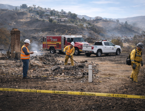
The Phase 1 testing for construction helps prevent project delays and closures. Properly framed inspections safeguard schedules, jobs and project budgets. The Los Angeles Department of Building and Safety says visual checks help catch early problems.
Scope of an Engineering Geology Report
The scope depends on the project. A house needs less study than a hospital. Still, most reports include similar steps. Following is the complete scope of the geology report.
Read more to find out why an Engineering Geology Report can help properly develop a property and construction stability, along with avoiding construction issues.

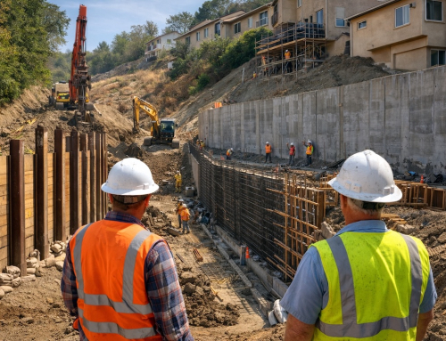
Engineering geology site investigation for a hillside residential project in Los Angeles, showing geologist and engineer reviewing soil reports, foundation plans, slope stability, and seismic design requirements for safe home construction in Southern California
Site Investigation for Engineering Geology Report
The process begins with a site visit. The engineering geologist walks the property. They observe surface features. They observe and investigate cracks, scarps, and indications of shakiness.
They examine drops in drainage patterns. They note slope angles. They review nearby construction. They also check old maps and aerial photos. Regional data from the The California Geological Survey may be reviewed.
Subsurface Investigation
Surface study is not enough. The ground must be tested. Drilling rigs create boreholes. Test pits may be excavated. Soil and rock samples are collected.
Each layer is logged. Depth and thickness are recorded. Laboratory tests measure strength and behavior. This is part of the geotechnical investigation process. Common tests include:
- Grain size analysis
- Plasticity tests
- Shear strength tests
- Density tests
Fault Evaluation
Faults can break the ground surface during an earthquake. In California, fault studies are required in special zones. The Alquist-Priolo Act regulates this. If needed, trenching may be done to confirm fault activity.
The engineering geologist checks:
- Location of known faults
- Distance from the site
- Evidence of recent movement
Seismic Hazard Assessment
Ground shaking affects foundations. Liquefaction occurs when loose sand loses strength during shaking. This can cause settlement or tilting.
The report evaluates:
- Seismic design parameters
- Liquefaction potential
- Lateral spreading risk
Slope Stability Analysis
Many Los Angeles properties are on hillsides. Slope failure can damage homes and roads. The report analyzes soil strength. It calculates safety factors. It recommends stabilization if needed. Solutions may include:
- Retaining walls
- Drainage systems
- Soil reinforcement
Groundwater Evaluation
Groundwater affects soil strength. High water levels can reduce stability. They can cause uplift pressure in basements. The report measures groundwater depth. It evaluates seasonal change. Drainage design may be recommended.
How an Engineering Geology Report Is Prepared
The preparation follows this process:
Step 1: Data Review
The geologist reviews public records. They study geological maps. They check seismic hazard maps. They review previous reports if available.
Step 2: Field Work
The team visits the site. They carry out drilling and sampling. Each soil layer is described. Rock fractures are noted. Photographs are taken. Coordinates are recorded.
Step 3: Laboratory Testing
A certified lab is selected, and samples are transferred there. Tests include measurement of strength, compressibility, and moisture content. These values are useful to the engineers to help design safe foundations.
Step 4: Engineering Analysis
The data is analyzed. Slope stability software may be used. Settlement calculations are performed. Seismic design parameters are determined. The analysis must follow California Building Code standards.
Step 5: Report Writing
The findings are documented. The report consists of text, maps, logs and recommendations. The report is signed and stamped by the office of licensed professional engineering geologist.
Key Components of the Report
A complete engineering geology report includes several parts. Each section has a clear purpose. Together, they create a full picture of site conditions.
- Project Description
This section explains the proposed development. It includes location and scope of work. It also describes site access and planned grading. This helps reviewers understand project impact.
- Regional Geology
This describes local rock formations and tectonic setting. It explains how the area was formed. It also identifies known regional faults.
- Site Conditions
This explains soil layers and rock types found during investigation. It includes boring logs and field observations. It may also describe undocumented fill.
- Hazard Analysis
This evaluates faults, liquefaction, landslides, and other risks. Each hazard is studied separately. Risk levels are clearly defined.
Engineering Recommendations
This is a section that provides good design guidance. It is the most important section of the report. Recommendations are based on field data and results of testing.
They must adhere to standards set by the building codes. They must follow building code standards. Ultimately, engineers use this section for the final design. Contractors also carry out all these guidelines in construction.
It may include:
- Foundation type
- Allowable bearing pressure
- Grading guidelines
- Drainage control
- Slope stabilization
Who Uses Engineering Geology Reports?
Many professionals depend on this document. It supports both design and approval processes.
Civil Engineers
They design foundations using soil data. They calculate settlement and bearing capacity. Their design depends on accurate soil strength values.
Structural Engineers
They use seismic parameters for structural safety. These values control lateral force design. Proper data improves earthquake performance.
Architects
They adjust building layout based on site limits. They may relocate structures away from fault zones or steep slopes.
Contractors
They plan excavation and shoring systems. They use soil data to select equipment and safety measures.
Government Agencies
Public agencies review the report before approval. They verify that hazards are addressed. They ensure public safety standards are met.
LADBS reviews hillside projects. Los Angeles County checks grading permits. Caltrans requires geological studies for highways. LA Metro requires subsurface investigation for rail projects.
Benefits of Engineering Geology Reports
The benefits are clear. The report adds value at every stage of development.
- Safety
It protects buildings from failure. It minimizes the risk of collapse, settlement and slope movement.
- Risk Reduction
It identifies hazards prior to the construction process. Early identification allows for design changes if major costs are to be eliminated.
- Cost Control
Early detection reduces change orders and delays. It prevents unexpected soil problems during excavation.
- Regulatory Approval
It supports permit approval in California jurisdictions. Without it, agencies may reject or delay applications.
- Better Planning
It is useful to teams involved in planning excavation and grading projects. This helps to improve the coordination between the engineers and the contractor.
Common Challenges
Even with a detailed study, some limits remain. Ground conditions can be complex.
Limited Exploration
Boreholes cover selected points only. Soil can vary between them. Hidden conditions may exist outside the tested areas.
Groundwater Change
The water levels vary with the season. Heavy rain or drought circumstances can impact the groundwater behavior in the long run.
Seismic Uncertainty
Earthquakes cannot be forecasted. Reports base estimates of risk on data. Actual shaking intensity may vary from projections.
Final Thoughts
An engineering geology report is essential for safe construction. It studies the ground. It identifies hazards. It supports design.
In Southern California, it is often required by law. Strong foundations begin with strong knowledge of the earth.
Without this report, risk increases. With it, projects move forward with confidence.
F.A.Q.s
- What is the schedule for preparing the geology report?
The schedule for the work on geology reports depends on the size and complexity of the particular project. For example, the residential projects may take a couple of weeks. Similarly, the huge commercial project may take a few months.
- Why do you think Liquefaction is important to mention within the report?
Liquefaction is a phenomenon of loosening of saturated soil mass. It loses its strength under an earthquake. This causes settling or tilting. Moreover, the report analyses liquefaction so that designs can be based on it.
Build with knowledge. Build with confidence. Build smart from the ground up.