Rebuilding efforts are ongoing throughout impacted communities from the Eaton Fire and Palisades Fire. Many property owners are undertaking residential rebuilding schemes, and information about the cost.
Homeowners are expecting higher costs after wildfires, such as site investigation. Properties may require geotechnical and topographic surveys before plans submission, and construction begins.
An investigation becomes important after the wildfires, especially for the recovery process, to determine the site condition for reconstruction. Certainly, it costs the homeowner, and the fee depends on the property’s size, accessibility, and terrain. However, the 2026 rebuilding guides suggest a $5,000 to $25,000 fee for a geotechnical and topographical survey.
Especially in Altadena or Pacific Palisades, homeowners can determine their expectations with this article. If they understand these costs, they would know what to do to avoid getting caught off guard or permit delays. We at Marshall Geoscience understand this best, and you can find out why.
Why Site Assessments Are Necessary After California Wildfires
Post-California wildfire site assessments are crucial that’s why The County started the LA County Recovers effort. The LA County Recovers website serves as a one-stop shop for residents to navigate the rebuilding process. LA wildfires impact homes, buildings, subgrade properties, destroy vegetation, increase erosion, and affect drainage. These changes can form hazards that may not be apparent on the surface.
Professionals can use the site inspection to identify the issues before the construction phase. Such assessments are particularly significant in hilly areas and building constructions. In the absence of investigations, rebuilding projects may face unforeseen engineering issues.
These issues and construction modifications lead to additional costs. Surveyors and engineers conduct an evaluation to determine:
- Soil stability
- Slope conditions
- Drainage patterns
- Foundation requirements
- Grading needs
- Potential geological hazards
Understanding Geotechnical Engineering for Fire Rebuilds
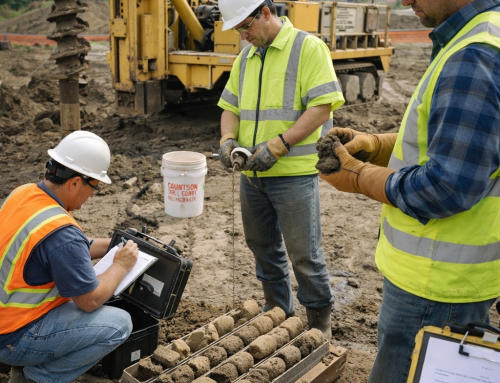
Geotechnical engineering can influence the cost of wildfire reconstruction. The geotechnical engineer examines the ground and underground properties of a property. The aim is to evaluate the ground for safe accommodation of a new building.
Soil sampling is a common practice after a wildfire to determine the impact. The investigation could involve:
Soil Borings
Soil samples are taken from the ground by drilling. We use these samples to ascertain the strength and composition of soil.
Laboratory Testing
The technicians collect the samples to determine engineering properties. During lab tests, the engineers can identify the expansive soils, weak layers, or drainage issues.
Groundwater Evaluation
Engineers assess the groundwater to determine underground conditions. Here, the groundwater level is one of the most important factors affecting the foundation performance.
Slope Stability
This is especially vital for construction projects on a hillside. Engineers decide if slopes are stable enough to rebuild.
The right post-wildire rebuild inspections prevent project delays and avoid risky project budget issues. Properly framed inspections safeguard schedules, jobs and your project budgets.
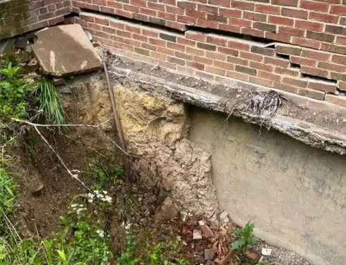
Wildfire Effects on Soil and Rock
Wildfire changes soil and rock at the chemical and physical level. Heat breaks down clay minerals. It burns organic matter that binds soil. The result is a weak structure that collapses under stress. Following are some harsh effects of wildfires on soil and rocks.
- One major effect is the hydrophobic layer. Plant waxes melt when burnt and seep out during the soil.
- After burning and on cooling, they create a water repulsive shell. This layer prevents infiltration.
- Rain runs off instead of sinking in. Runoff concentrates in channels. Flash floods and debris flows follow.
- Wildfire also alters rock. Heat and cooling cycles cause spalling.
- Surface layers crack and peel away. Fractures deepen in the rocks. In sandstone and shale, expansion creates new breaks. In granite, outer layers split off. Both Altadena and Pacific Palisades showed these changes.
- In Altadena, hydrophobic soils triggered flash floods. Geotechnical soil reports from the area confirmed weaker near-surface layers.
- In Pacific Palisades, cliffs shed rock fragments after heating. Rockfalls were common along canyon roads.
The California Geological Survey (CGS) has studied these effects across the state. Their reports show that soils may take years to recover structure.
In some cases, burned slopes never regain full infiltration ability. This leaves them prone to chronic erosion.
Read more to find out why every natural disaster like fires and floods require a comprehensive structural and foundational analysis before any rebuild can occur.

Surveyors and geotechnical engineers assessing a wildfire-damaged hillside property in Pacific Palisades to support post-fire rebuilding, foundation design, and permitting requirements.
What Is a Topographic Survey?
A topographic survey is a mapping process to show all the topographic features. The maps are helpful in the design phase before planning the grading or applying for a permit.
Appropriate post-wildfire survey data will enable the reconstruction to meet up-to-date building and zoning codes. This survey will supply accurate information regarding:
- Ground elevations
- Existing grades
- Drainage channels
- Retaining walls
- Utility locations
- Trees and vegetation
- Property boundaries
Post-wildfire Survey Cost in LA
Soil conditions don’t remain the same after a wildfire, and a thorough survey is important. It may primarily include geotechnical and topographic surveys, but it costs the property owner, such as:
Geotechnical Survey
Many homeowners ask about the geotechnical survey cost after a wildfire, but there is no clear answer. These include:
- Lot size
- Soil conditions
- Accessibility
- Required number of borings
- Slope steepness
- Geological complexity
Typically, simple residential lots do not need as much investigation. Engineers need to analyze and test soil for more complex soil properties. Some potential geotechnical engineering expenses include:
- Site visits
- Drilling services
- Soil field testing
- Laboratory Testing
- Engineering evaluations
- Final reporting
Therefore, the cost of geotechnical surveys can differ considerably between properties. However, topographic maps cost $25 each for California.
Topographic Survey
The cost of the topographic survey in California depends on the project’s needs and site conditions. In many cases, properties in Pacific Palisades and Altadena have complex terrain, which can make overall surveying more expensive. Sometimes, the city and local agencies like the California Geological Survey can provide these topographical surveys. The cost of surveys is influenced by the following:
Property Size
More field measurements and data collection are necessary for larger properties.
Terrain Complexity
A survey in steep terrain will require more time and effort
Existing Structures
Some buildings and debris may hinder surveying.
Access Conditions
Access may be difficult and may require special equipment.
Why are Hillside Construction Survey Costs Higher?
The majority of properties impacted by the Palisades Fire are in hillside areas. The costs of investigation are higher with hillside construction. This means that the construction survey of a hillside site is generally more expensive than a flat residential site.
The additional investment helps minimize long-term risks and provides safer construction. Engineers must evaluate:
- Slope stability
- Erosion risks
- Retaining wall requirements
- Drainage performance
- Soil movement potential
- Higher fieldwork
Altadena Rebuild Costs and Site Investigation Requirements
The budget concern for the Altadena reconstruction is growing because the investigation is an important part of it. Site investigations incur a low percentage of the construction cost, but we must complete them before the permit. Failure to investigate these may lead to delays and future costs for the project. The costs of rebuilding Altadena can include:
- Debris removal
- Site assessment
- Geotechnical engineering studies
- Topographic surveys
- Architectural design
- Structural engineering
- Permitting fees
- Construction expenses
Pacific Palisades Recovery and Rebuilding Challenges
The challenges facing recovery and rebuilding in the City of Pacific Palisades. Because of its terrain, there are unique challenges to the recovery work in Pacific Palisades.
Numerous residential properties sit on slopes that face canyons or the sea level. These are the conditions that necessitate detailed engineering evaluations, and if you plan a building, you’ll be able to see problems before starting it.
A guide to the reconstruction of the Pacific Palisades usually suggests that you consult with:
- Geotechnical engineers
- Surveyors
- Civil engineers
- Structural engineers
Topographic Surveys for Rebuilding Permits
Rebuilding permits require a topographic survey; however, some places have topographic maps. Survey information supports reviewers to verify:
- Property boundaries
- Setbacks
- Building locations
- Drainage systems
- Grading plans
Permit agencies such as LADBS and the State of California need accurate survey information to ensure compliance with local regulations. The permit application may proceed slowly without an up-to-date topographic survey.
Common post-wildfire Rebuilding Expenses
Having survey information up front can help to streamline the approval process. The typical expenses that may occur after a fire. Post-fire rebuilding projects incur a variety of additional costs.
Property owners should be aware of these costs while estimating the project budget. These may include:
- Engineering Fees:
Engineering consultants evaluate site conditions and make a technical report.
- Surveying Costs:
Soil surveyors collect soil data to assist design and permitting.
- Environmental Reviews:
Some projects require an environmental assessment before construction.
- Permit Fees:
Local agencies impose a fee for the permit and review process.
- Grading and Drainage Design:
Civil Engineers create water and site-level plans.
Reducing Wildfire Reconstruction Costs
Some simple steps can reduce the cost of post-wildfire reconstruction, such as;
- The most important thing to consider is the mutual coordination. If engineers, architects, and contractors coordinate, then they lead to better project results. If we coordinate the reconstruction efforts efficiently, the process will be easier.
- We can minimize the post-fire rebuilding expenses with proper planning. Earlier investigations can be better for property owners because early engineering studies can:
- Brainstorm possible limitations of the site.
- List the potential site limitations.
- Improve design efficiency
- Reduce construction changes
- Facilitate a quicker permitting process
- Minimize project delays
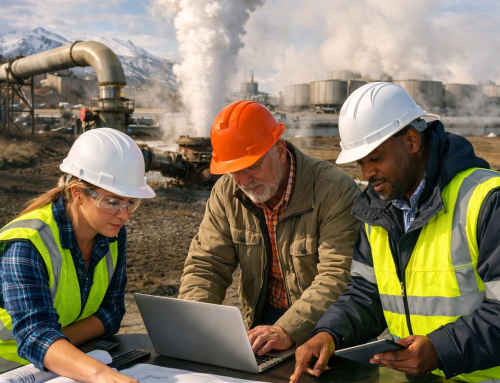
Selecting The Best Geotechnical Engineering Team in LA
A professional team is important for successful post-fire rebuilding projects. Consultants have a good knowledge of local laws and geology. For example, LADBS rules, California Building Codes, and other local jurisdictions. They can help to avoid costly errors in the construction process. Be sure to search for companies that have experience with:
- Geotechnical engineering
- Wildfire rebuilding
- Hillside construction
- Foundation design
- Soil investigation
- Topographic surveying
- Site assessment services
Long-Term Benefits of Geotechnical and Topographic Surveys
The geotechnical and topographical surveys have long-term benefits. Sometimes, the homeowner considers the survey cost as an extra.
Data collected during the site investigation will help with safer and longer-lasting rebuilding projects. These studies help in successful reconstruction after the Eaton Fire and Palisades Fire. Benefits include:
- Improved site safety
- Better foundation performance
- Reduced settlement risks
- Drainage system development is more effective.
- Faster permit approvals
- Fewer construction surprises
Conclusion
Eaton and Palisades Fire rebuilding efforts are the largest in recent California history. Altadena and Pacific Palisades are in the reconstruction phase. That’s why it’s important to understand the necessity of geotechnical engineering and topographic surveys.
However, hillside construction sites may require more extensive investigation. These costs depend on the complexity of the terrain, the soil conditions, the slope stability requirements, and permitting requirements.
While these studies add rebuilding costs after a fire, they play a key role. They help design the foundation, assess the site, and secure permits. They also support long-term structural safety.
A proper soil investigation and survey can reduce risks and save money. It helps homeowners rebuild their homes with confidence after a California wildfire.

Build with knowledge. Build with confidence. Build smart from the ground up.