Engineering geology studies interaction of earthy materials. It also comprises the rocks, topography and the interaction of human activity. It shows how ground conditions affect construction and hazard safety.
During disasters, this field is vital. Engineers use it to design safe structures. They also depend on it to reduce life-threatening risks.
Wildfires are now one of California’s most destructive forces. Climate change has made them larger and more frequent. Hotter summers and longer droughts leave vegetation dry. Strong winds push flames into communities. Los Angeles County has seen this pattern often.
Two fires highlight the connection between wildfire and geology. The Eaton Fire in Altadena burned steep foothill slopes. The Palisades Fire in Pacific Palisades scarred fragile coastal cliffs and canyons. Each fire produced hazards tied directly to geology.
This article examines how wildfire changes soil and rock. It also explains slope instability, erosion, and hazard mapping. It looks at lessons for planning and recovery in Southern California. Geology not only shapes fire damage. It also guides safe rebuilding.
Eaton Fire in Altadena: Geological Setting
Altadena sits against the San Gabriel Mountains. This range rises fast from the Los Angeles Basin. Slopes are steep. Canyons are narrow and cut deep into fractured rock.
Large alluvial fans at the mouth of the canyons disperse. These followers are comprised of boulders, gravel, sand and silt deposited. It was mainly due to former floods and landslides.
The Eaton Fire burned through this setting. Chaparral and native grasses once covered slopes. Their roots held soil in place. Fire stripped the surface bare.
Heavy rain soon followed. Water rushed down the slopes. It picked up ash, soil, and loose rock. Debris surged into drainage channels and canyons.
The geology magnified the danger. Bedrock in this case is fractured and weathered. Alluvial fan depositions are unconsolidated and loose. Without vegetation, slopes lost cohesion. Gullies feeding into Eaton Canyon eroded faster.
The fire also changed water flow. Blocked culverts and scorched ground rerouted runoff. Flooding risk increased in neighborhoods below.
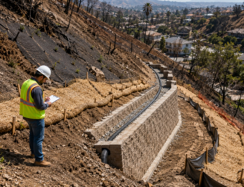
The check dam and debris basins constructed. This step was taken by the engineers with Los Angeles County Public Works were after the fire. These measures were designed to slow and capture flow. The geology dictated every step of recovery.
Palisades Fire in Pacific Palisades: Geological Setting
Palisades Fire took place on a seaside location. Pacific Palisades is a coastal city situated up on cliffs. It has 200-300 feet high cliffs in some areas.
The rock is of a sedimentary nature that comprises mostly of sandstone and shale. All these constructions are classified into layers, the weak, and tend to slide when they get wet.
Steep drainage canyons leading to the coast were burnt by fire. Thin soils lost vegetation anchors. Heavy rain soon triggered slides. Roads in canyon bottoms were blocked. Homes near cliff edges faced rockfall danger.
The coastal geology is unstable even without fire. Waves undercut cliffs. Rainwater seeps into cracks, softening shale layers. Fire added new stresses. Heat fractured rocks.
Slopes that were already weak became more unstable. Hazards multiplied. Rockfalls dropped onto Pacific Coast Highway. Cracks appeared near canyon rims.
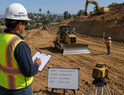
Engineers from LADBS and LA County geologists surveyed slopes. They mapped dangerous areas before permits were reissued. In some zones, retaining walls and soil nails were required before rebuilding.
The right inspections prevent project delays and the risky projects or the budgets. Properly framed inspections safeguard schedules, jobs and project budgets. I
Wildfire Effects on Soil and Rock
Wildfire changes soil and rock at the chemical and physical level. Heat breaks down clay minerals. It burns organic matter that binds soil. The result is a weak structure that collapses under stress. Following are some harsh effects of wildfires on soil and rocks.
- One major effect is the hydrophobic layer. Plant waxes melt when burnt and seep out during the soil.
- After burning and on cooling, they create a water repulsive shell. This layer prevents infiltration.
- Rain runs off instead of sinking in. Runoff concentrates in channels. Flash floods and debris flows follow.
- Wildfire also alters rock. Heat and cooling cycles cause spalling.
- Surface layers crack and peel away. Fractures deepen in the rocks. In sandstone and shale, expansion creates new breaks. In granite, outer layers split off. Both Altadena and Pacific Palisades showed these changes.
- In Altadena, hydrophobic soils triggered flash floods. Geotechnical soil reports from the area confirmed weaker near-surface layers.
- In Pacific Palisades, cliffs shed rock fragments after heating. Rockfalls were common along canyon roads.
The California Geological Survey (CGS) has studied these effects across the state. Their reports show that soils may take years to recover structure.
In some cases, burned slopes never regain full infiltration ability. This leaves them prone to chronic erosion.
Read more to find out why every natural disaster like fires and floods require a comprehensive structural and foundational analysis before any rebuild can occur.

Wildfire meets geology: scorched foothill slopes of Altadena and eroded coastal cliffs of Pacific Palisades, showing how fire reshapes California’s landscapes
Slope Stability and Erosion
Slope stability is a major concern in post-fire landscapes. Vegetation provides root reinforcement. Roots interlock with soil and rock. However, the post fire circumstances would be:
- Fire removes the interlocking system of roots. Slopes lose both cohesion and friction.
- Rainfall then triggers failures. Los Angeles history shows the risk.
- The winter storms carrying debris after the 2009 Station Fire resulted in large debris flows. Wholesale streets were cocked in mud and boulders in the La Ca twindrade Flintridge.
- Families lost homes. The cycle repeated after the Eaton Fire.
- Alluvial fans collected sudden surges of debris.
- The Palisades Fire brought a different hazard. Coastal cliffs lost their thin soil cover.
- Sandstone and shale beds lay bare. Small slides cascaded down canyons.
Rockfalls struck roads and threatened nearby homes. Geology decides the hazard scale. In Altadena, unconsolidated alluvium meant debris flows were likely.
In the Palisades, weak sedimentary rocks meant cliff failures dominated. Engineers used slope stability models. They calculated factors of safety for different slopes. Designs for retaining walls, shotcrete, and soil nails were guided by these results.
Hazard Mapping and Monitoring
After a fire, hazard mapping becomes essential. It identifies unstable slopes and guides safety plans. Monitoring is long term. Soil recovery can take decades. Some slopes never stabilize.
Agencies in Southern California use advanced tools. These tools help track landslide risk in near real time.
- Caltrans surveys slopes along highways.
- LADBS monitors hillside neighborhoods.
- Drones provide aerial imagery.
- LiDAR scans detect ground shifts as small as a few centimeters.
However, monitoring and hazard mapping contributed following these fires as:
- For the Eaton Fire, hazard maps marked debris flow zones.
- Warning systems were installed in key canyons.
- For the Palisades Fire, focus shifted to cliffs and canyon roads. Engineers inspected cracks and rockfalls.
- CGS updates landslide and debris flow maps for fire-burned zones. These maps inform LADBS permits, Caltrans Road repairs, and LA County flood control plans.
- The Los Angeles County Flood Control District maintains a network of debris basins. Many of these basins were built after past fires. After the Eaton Fire, they were expanded to capture flows from burned slopes.
Lessons for Engineering Geology
The fires show why engineering geology is critical. It is not a separate step. It is central to disaster recovery. Here are some important lessons, wildfires taught for geology.
- One lesson is integration. Geological work must link with hydrology, ecology, and engineering. Recovery requires a system approach. The stabilization of the slope, drainage, and the vegetation regrowth should be determined.
- The other one is land-use planning. Los Angeles continues to expand into hillside areas. Many of these areas are high fire risk. Engineering geology highlights safe and unsafe zones.
- It guides zoning laws. It also shapes building codes for hillside foundations and retaining walls. Best practices have emerged. After the Eaton Fire, check dams and debris basins helped reduce debris flows.
- After the Palisades Fire, soil nails and retaining walls stabilized cliffs. Both responses depended on geological studies.
Agencies enforce these lessons. The county of Public Works and Metro and Caltrans of Los Angeles need approval for projects within the burned zones. They require the permits with the input of geotechnical and geological services.
California Geological Survey also offers hazard maps of the state. Together, they set standards for recovery. This lesson was reinstated by the 2018 Woolsey Fire. It scalded Malibu and those in Ventura County.
Months later, heavy rains caused landslides. Many homes had been built without full slope stability checks. The result was costly damage. Engineering geology must remain central in planning to avoid repeats.
Conclusion
Wildfires reshape landscapes as much as they destroy vegetation. The Eaton Fire in Altadena and the Palisades Fire in Pacific Palisades show this link.
One burned foothill alluvium. The other scarred coastal cliffs. Both revealed how geology shapes hazard severity. It also determines long-term recovery outcomes for nearby communities.
Engineering geology is more than a technical field. It is the foundation of safe recovery. It guides slope stabilization, debris control, drainage planning, and land-use policy. It reduces future risks.
Los Angeles will face more wildfires. Climate change makes this certain. Geology must remain central in hazard planning and emergency preparedness. It is more specific for cities and rural zones.
It must guide where homes are built and how roads are protected. By learning from past fires, Southern California can grow stronger. Resilience depends on respecting geology and applying lessons through science-driven planning.
If you have been affected by the Eaton Canyon Altadena or Pacific Palisades Fires, please contact Our Geotechnical and Environmental Engineers.
Build with knowledge. Build with confidence. Build smart from the ground up.