The geological mapping is the initial action towards safe site work. It demonstrates what is under the ground. It exposes the type of rocks, layer of soil, and structure. These are the data that enable engineers to select the appropriate design.
Site analysis involves geological mapping, which minimizes the risk. These maps depict the topography and indicate the faults that are active. It determines weak soil and groundwater areas. In case of seismic areas, geological mapping is important.
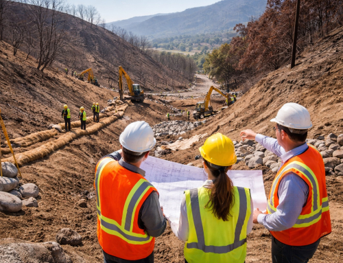
Similarly, the Southern California terrain is complicated and has active faults. The complexity of that increases the necessity to study it.
Reviews of geology are customary to LADBS and the California Geological Survey. These reviews secure the lives and properties.
What is Geological Mapping?
Geological mapping documents the location of the Earth. It plots the positions of these rock and soil on the surface. It is also able to capture the undiscovered characteristics, like fractures and seams.
Further, the underground soil information is provided in boreholes, trenches and test pits. Field notes and laboratory data provide interest and figures. These are inputs that constitute a map and a geotechnical report.
The map indicates the spatial distribution of materials. The report gives the engineering properties of these materials. The two of them also inform design decisions.
Mapping engineering requirements to geology. It is used to determine the behavior of the ground under loads. It is also beneficial in fulfilling local code and permitting requirements.
Key Tools Used in Geological Mapping
In most instances, field tools are still needed but they are not hi-tech. A compass clinometer is used to measure the orientation of layers. A rock hammer assists in halting new surfaces.
A hand lens enables the geologist to view the grains and minerals at a close. Thicknesses are measured by the use of tape measures and marked poles. Rock and soil samples are arranged in sample bags and tags.
Features and samples are accurately logged by GPS units. The mobile gadgets enable teams to take notes and pictures on the field. Introductory devices go along with sophisticated systems.
GIS receives GPS points to be mapped. The data is stored and represented in GIS programs like ArcGIS or QGIS. There are lineaments and large features depicted by aerial and satellite images. Drones are used to survey steep and unsafe places.
LIDAR develops very detailed terrain images. Subsurface sampling instruments include augers and corers that take samples. Key engineering properties are then found by lab tests.
The right inspections prevent project delays and the risky projects or the budgets. Properly framed inspections safeguard schedules, jobs and project budgets. I
Essential Techniques for Site Analysis
Mapping starts with a planned field program. Teams are out of the transects and outcrops. They record the type of rock, type of grain and extent of weathering. They record the strike and dip in numerous points.
They indicate the faults, folds and joints. They capture relationship of bedding and contacts. They take soil and rock samples to the laboratory.
Boreholes and trenches give underground information. Central logging indicates sequence and structure of layers. Out of these data, columns of stratigraphy are constructed. Profiles give a picture of the profile of the subsurface.
Cross-sections show the ways of dip and fold of the layers underground. The structural interpretation correlates what is seen with the dangers of the stability.
Indicatively, fractured rock can be load-bearing. Likewise, fine sand would melt beneath the water table when there is an earthquake. Besides, soil layers can be swollen due to moisture variations. Designing these conditions by mapping.
Read more to find out Why Geological Mapping is Important in Site Analysis!

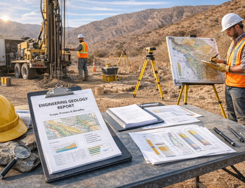
Geologist Conducting Fieldwork on Construction Site: Analyzing Sedimentary Layers with Geological Tools
Integrating Geological Maps with Engineering Design
Design work takes input from geological maps. Maps are used by engineers to select the type of foundation. As an illustration, shallow footings can be used in case the bedrock is close to the surface. In case the soils are soft, piles or deep foundations can be required.
Groundwater and perched water areas are depicted in maps. They control the planning of dewatering and excavation.
In the case of slope work, the slope showed the possible planes of failure. For tunnels, maps indicate weak rock masses and fault zones that should or should not be bored.
There must be stable corridors over roads and bridges. Maps are used in steering away route lines of loose land.
The preliminary mapping minimizes the unexpected during construction. It reduces cost and time schedule risk too. The LADBS, Caltrans and Metro project approvals usually depend on these inputs.
GIS and Remote Sensing in Modern Mapping
The main element of geological mapping today is GIS. It takes field points, photographs and lab findings. It enables one to overlay geology, topography and hydrology.
Analysts are able to execute spatial queries as well as export clean maps. In LIDAR and drone images, extensive digital heights are generated. Based on these models, angles of slope and drainage paths are derived within teams.
Slope stability models are fed on these metrics. The change with time can be detected by remote sensing. Slow ground motion can be observed by InSAR. The data is used to keep a check on infrastructure and long-term trends.
Software such as RockWorks helps in cross-section construction and data plotting. California Geological Survey offers map data that can be imported to GIS. Such data sets are useful in satisfying seismic zoning and fault mapping needs.
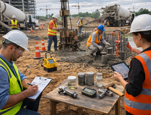
Lab Testing and Why it Matters?
Field observations are provided with numerical data that is obtained through laboratory tests. The soils are classified using grain-size analysis. Plasticity of fine soils is presented at Atterberg limits. The strength is measured using triaxial and direct shear test.
Compressibility and settlement potential are indicated by the tests of consolidation. The point-load or unconfined compressive strength tests may be performed on rock samples.
These tests inform the designer of the manner in which the ground will respond to load. Numerical models are fed with test results.
Settlement, bearing capacity and slope stability are predicted using models. This connection between the laboratory and the model is essential to the safety design and cost management.
Best Practices in the Field & Practical Workflow
Here are some best practices following a practical workflow. One must adhere to it for good results.
- Sequencing at the beginning of the lifecycle.
- Characterize the field of study and gateways.
- Pointing utilities and fences.
- Arrange the spacing between plan boreholes to keep up with variation at the site.
- In urban locations, there will be little accessibility and more in-depth utilities. To work in a steep landscape, safety and position have to be planned.
- A clear record should be preserved of samples. Each sample should be marked with the day, depth, and place.
- Utilize standard test procedures, i.e,. as specified in ASTM or AASHTO. Develop documents, boundaries, and assumptions in the report.
- Make available borehole logs, cross-sections and maps. These factors accelerate the reviews by the local agencies.
Local Compliance and Agency Guidance
In California, local guidance is important to projects. The California Geological Survey provides state mapping and advice.
LADBS establishes local regulations for the projects in Los Angeles. Caltrans offers geotechnical standards for highways and bridges.
Transit and road projects have certain requirements in LA Metro and county public works. Special attention is given to the Alquist-Priolo Act and the Seismic Hazard Mapping Act along faults.
The project teams ought to verify agency checklists at an early stage. By providing full reports, changes and orders in review are minimized.
Case Studies and Value of Good Mapping
The worth of study work is exhibited in real projects. One road alignment detected a concealed landslide scarp by using LIDAR.
The crew did not need to make expensive repairs as they were rerouting. Dense boreholes were used in an urban building site; a shallow layer of liquefiable was found.
The construction was redesigned as deep foundations and it was not prone to failure. Transit tunnels are based on current geologic maps. These maps direct the plans of lining and grouting.
In both instances, pre-kick mapping was cost-saving and enhanced safety.
Conclusion
Site analysis consists of a critical step of geological mapping of safe projects. It is an integrated approach of fieldwork, laboratory tests, and computer mapping.
Geology is converted to engineering activities through maps. They facilitate foundation selection, slope design and routing.
In Southern California, code and agencies usually require mapping. Hire a geologist and a licensed geotechnical engineer.
Have them, give them specific maps, cross-sections and lab reports. The hazard risks can be minimized by an adequate mapping of the site. It also confines the project cost within the budget.
For a professional opinion on-site, call a licensed geologist or geotechnical engineer. Mapping is a good way of saving lives and property. Hire experts early on.
Hire Marshall Geo Engineering Consultants for Reliable Site Analysis.
The construction work always starts with the ground on which it is built. Ground is something to do with professionals. Allow Marshall Geo to enable you to base your building on a sound foundation.
At MarshallGeo.com, there are professional geologists and engineers. The team offers full mapping services.
They provide site analysis, soil testing, and geological mapping throughout California. High-end GIS, drone mapping, and LIDAR technologies are used to detect possible threats.
They are trusted mapping partners for small as well as large projects. The data are up to the standards of LADBS, Caltrans and the California Geological Survey.
Give Marshall Geo the next project and make sure it is safe, compliant, and economical. Request a proposal for geological mapping or call MarshallGeo.com today to have a consultation.
Build with knowledge. Build with confidence. Build smart from the ground up.